INTRODUCTION
We are facing the greatest challenge that humanity has ever known through the struggles agains :
- Global warming, acidification and rising oceans, changes in ocean currents.
- The collapse of biodiversity (58% in 42 years, while we know only 15% of marine species).
- Pollution (Micropollutants, Microplastics, Cocktail effects…)
The window of opportunity to act is closing and is estimated between 20 and 30 year.
Plankton is the lung of the planet. These people represent 95% of the marine biomass and produce one out of every two puffs of oxygen that we breathe.
The micro-skeletons and shells transform with time the CO2 of the atmosphere into calcareous deposit.
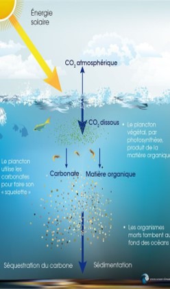
Among marine species, plankton are the main markers of the health of our planet because they form the first rung of the oceanic food chain and have a very short life cycle.
THE NEED
We lack the time and the tools to analyze the share and the mechanisms of the various pressures on the oceanic ecosystem as they are so numerous: modifications of the atmosphere, increase of the sea temperature, decrease of oxygen, acidification, modification of the currents, overfishing, micropollutants: organic, mineral, chemical (110,000 substances), radioactive, sound…
The quantity of phytoplankton is collapsing (-10% in 150 years in Greenland, -30% in 16 years in the western Indian Ocean), we must understand why.
Plankton is dying, the ocean is dying. And if the ocean dies, we die too
We need to understand in real time the action of each of the levers of this complex climate machine, to have very quickly the means to monitor in real time the various markers of the planet.
If we can easily measure in the ocean physico-chemical parameters such as temperature, acidity, dissolved gases, salinity …, it is not the same for the direct counting of marine species as we would do with land species.
This project proposes a solution to quickly quantify and classify, at low cost and on a global scale, the microscopic life of aquatic environments (phytoplankton, zooplankton) as well as other microparticles in suspension such as microplastics, microbubbles, sediments (quartz, carbonates, silicates).
THE GENESIS
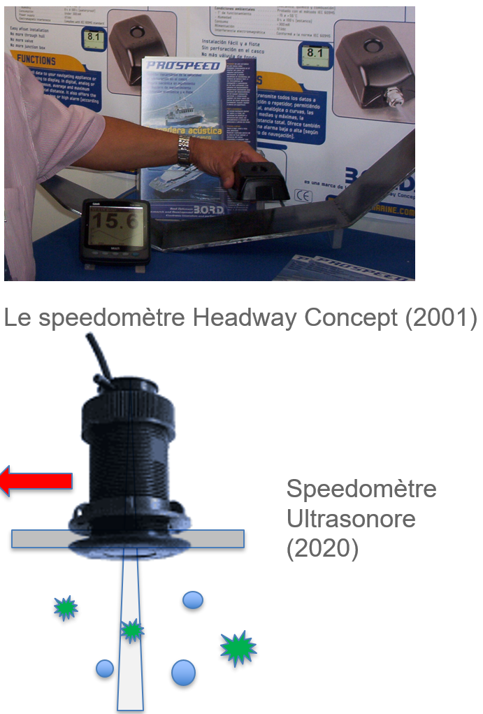
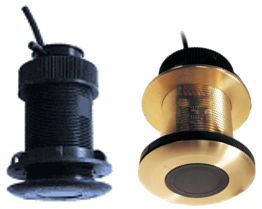
In 2001, Philippe Raude (Austral Electronics) invented a speedometer measuring the speed of a ship, without contact with water, without moving mechanics and through the hull. Magic!
The technology used is based on the echography of sea water via a very high frequency acoustic image processing on echoes mainly of plankton and microbubbles in suspension.
In 2 decades, this technology has been proven in surface measurements through hundreds of round-the-world tours, expeditions to the poles, but also in underwater measurements on diving thrusters and trawl sensors. Life is everywhere.
This project is made possible by the meeting of 3 passionate underwater acoustics experts as well as by the arrival of new technologies :
- In 2014: Advances in sonar signal modeling & processing as well as in reverse engineering of the biological related to research work in the framework of a sonar improvement (P. Raude/Austral & X. Demoulin/Marée).
- In 2019: Advances in AI applied to underwater acoustics (Caroline Magnier/ABYSsens)
THE PRINCIPLE
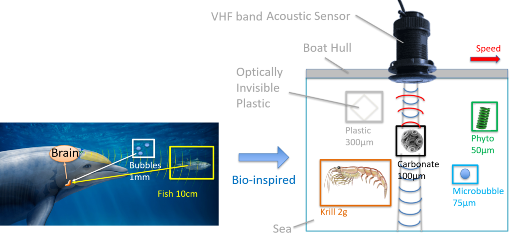
The sensor is inspired by the living (sonar principle, forms of signals emitted, processing of echoes), but it uses frequencies up to 1000 times higher.
In order to see the infinitesimal, the ultrasounds used are in the VHF radio band, the range is reduced to a few decimeters.
We want to use the general principle of field surveys and the proven seawater ultrasound technology, but with some evolutions:
- Improved finesse of the acoustic imaging
- Several frequencies and types of bio-inspired classifying modulations to better identify echoes
- Current calculation
- Addition of pre-processed data storage in the sensor
- Transmission of data at port of call to an AI to perform statistics on the echoes of the navigation
SENSOR FEATURES
- Speedometer-Sounder-Water Temperature (For the general public, an eco-responsible and participative purchase that replaces 2 sensors)
- Ultra accurate surface speed and approach sounder, no moving parts and no maintenance.
- Installation afloat is possible (it physically replaces a standard NMEA2000 sensor).
- Current meter (field survey of marine currents)
- By retrieving compass and GPS information from the NMEA2000 bus, the sensor calculates and datalogs the current.
- Micrometric sonar (in situ, automatic and non-destructive analysis of the ocean)
- Multi-frequency
- Several types of bio-inspired classifying modulations.
- Beam width of 6mm and up to 50cm depth (depending on the frequency).
- Pre-processing of echoes (boxes, IA format, compression).
- Data broadcasting to a server
- Internal datalog of echoes over 30 days, then WIFI / SDCARD broadcast during stopovers.
- In the future, via WIFI and StarLink.
- Remote AI processing and dissemination of statistics to the scientific community
- Objective: Quantification (Quantity, Size/Assembly, Mass) and Classification (Hardness, Acoustic Impedance) :
- Biomass (Gas bladder, lipid)
- Carbonate (skeleton, shell)
- Microplastics (hard, soft, fiber)
- Microbubbles
- Sediment (Quartz, silicate)
- Objective: Quantification (Quantity, Size/Assembly, Mass) and Classification (Hardness, Acoustic Impedance) :
OUR VISION
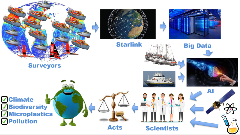
The vision is to start deploying in 3 years a fleet of thousands of surveyors on the oceans, we will then take advantage of the navigations in order to collect in an automated way oceano-scientific data.
These data will be complementary to satellite images and physical-chemical and biological field data.
This diagnostic tool is crucial for scientists at the bedside of our earth to :
- Better understand the mechanisms of the climate machine and our environmental pressures
- Find and validate solutions
- Monitor the long-term effects of future geoengineering laws and operations
It will probably take hundreds of years before we return to the pre-industrial earth.
SURFACE SURVEY
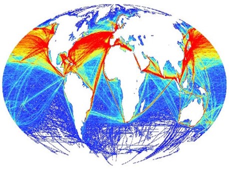
he Southern Ocean and the poles are poorly covered
One sensor allows to analyze per year :
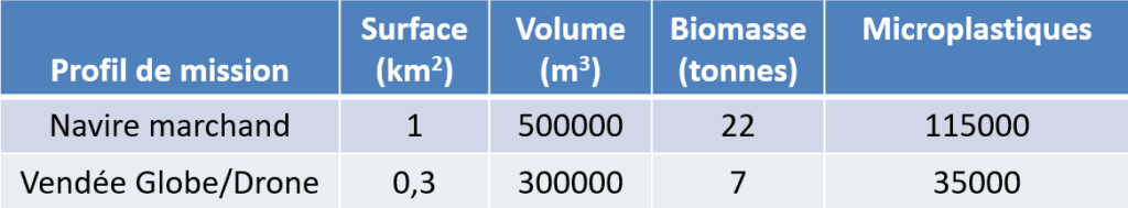
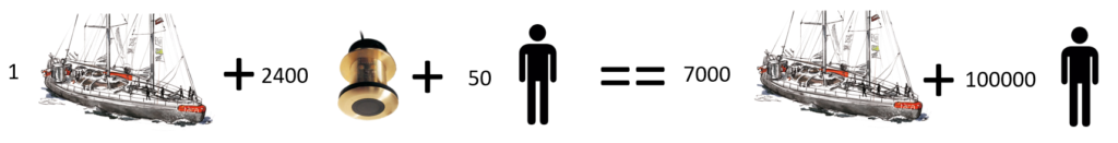
With a margin of error of 2% and 95% confidence level, it is necessary to analyze 2400 km2 out of the 362 000 000 km2 of the oceans, i.e. 2400 ships for an annual follow-up (9600 per quarter).
Objective: Equip 1% of the offshore vessels (cargo, fishing, island link…).
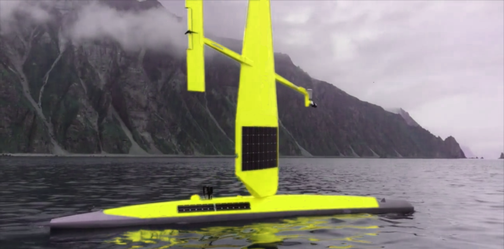
The distribution must be uniform and implies equipping drones and sailboats near the poles, especially since the poles are the main CO2 pumps.
In terms of volume of water analyzed, and in a somewhat simplistic way, the system will eventually be equivalent to 7000 scientific vessels and about 100000 scientists and sailors.
In this vision, the scientific vessels continuously reinforce the learning of the AI via training data.
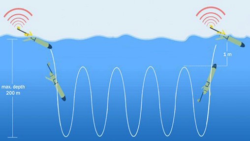
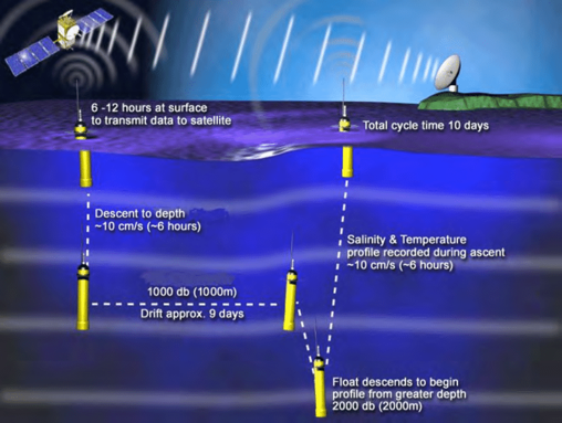
UNDERWATER SURVEY
The sensor fits perfectly into the :
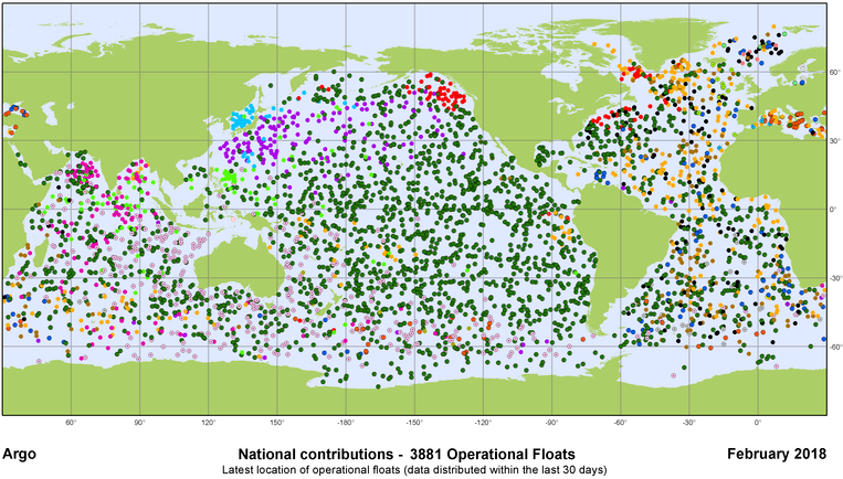
- ARGO Profilers (International program of nearly 4000 drifters doing immersion cycles)
- Gliders (underwater planners)
SCHEDULE
- T0 :
- Scientific and academic partners defined
- Financing of the first phase of the project
- T0 + 2 years :
- Proof of concept (Simulations, Prototypes, Test benches, AI training on samples, Sea trials…)
- T0 + 3 years :
- Industrialized sensor
- Infrastructures: Data server, AI computer
- Training of the AI at the base
- Start of statistics dissemination to scientists
- Start of deployment
- T0 + 6 years :
- Deployment completed for annual statistical monitoring (2400 offshore vessels/drones and 3800 underwater profilers)
- Continuous learning of the AI
- Automatic pollution alerts on bio-markers
A UNIFYING PROJECT
- The issue concerns the future of humanity and involves us all.
- Web and video communication will be in English and French to raise global awareness.
A PARTICIPATIVE PROJECT
- Scientists : Climate, Marine biology, Pollution, Data, Sailors…
- Companies : Autonomous devices (buoys, drones, profilers…)
- Shipowners, sailors, yachtsmen : Eco-responsible navigation
- Personalities, environmental protection associations
- General public : AI in cooperative calculation possible if it is ecologically judicious
THE CONTRIBUTIONS OF THE PROJECT
- Important contribution for the future of the planet :
- Plankton is one of the main keys to understanding our complex climate machine.
- Understand the decline of phytoplankton, monitor the biodiversity and health of oceans, lakes, rivers…
- Follow the modifications of marine currents
- Health: Microplastics in the food chain
- Bio-markers: Early detection and monitoring of pollution
- Study and validation of geo-engineering / cleaning operations
- A media and technological showcase for all partners
- Creation of highly technical jobs
THE TEAM
Philippe Raude : Manager of Austral Electronics
Engineer (Electronics, Embedded Computing, Command and Control, Underwater Acoustics)
Xavier Demoulin : Manager of Maree
PhD Engineer (Underwater acoustics, marine geophysics)
Caroline Magnier : Manager of Abyssens
PhD engineer (signal processing, underwater acoustics, AI)
PROJECT CONTACT
AUSTRAL ELECTRONICS
Parc Technologique de Soye
Espace TEKNICA
4 rue Galilee
56270 PLOEMEUR
FRANCE
Mail : contact@austral-eng.com
Skype : live:.cid.c9ce8511a29b439e
Mobile: +33 (0) 6 04 15 28 80